वापस जायें / Back
Geography of India - General
Area – 31,66,414 sq. Kilometers. It is the seventh larges country in the World in area.
Population – 130 crores. It is the second most populous country in the World after China.
Location and Extent
- 08° 04' N to 37° 06' N latitude and 68° 07' E to 97° 25' E longitude.
- Its length from North to South is 3,214 Kilometers.
- Its width from west to east is 2,933 Kilometers.
- The length of its land boundary is 15,200 Kilometers.
- The length of its sea coast is 7,517 Kilometers.
- Its total area is 31,66,414 square Kilometers
- Boundaries – North-west – Pakistan and Afghanistan, North - Tibet (now in China), China, Nepal and Bhutan, East Bangladesh and Myanmar.
- Andaman and Nicobar islands in Bay of Bengal and Lakshadweep islands in Arabian Sea are part of India.
- The Southern ocean boundary of India therefore touches Maldives in South West, Sri Lanka in South and Thailand and Indonesia in South East.
- India has both land and ocean boundaries with Pakistan, Bangladesh and Myanmar.
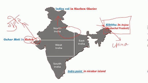
- The northernmost point of India is Indira Col in Siachen Glacier and southernmost point is India Point. The eastern most point of India is Kibithu and westernmost point is Ghuar Moti, located in the Kutch District of Gujarat located near the disputed Sir Creek. The southern most point of the main land is Kanyakumari. The northern most point India Col was named by the explorer Bullock Workman, after one of the names of the goddess Lakshmi in 1912. It has nothing to do with the name of Prime Minister Indira Gandhi.