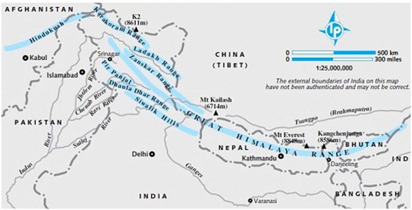
Passes – The high mountains of Himalayas can be crossed only at certain places where there are passes. In the North-West there are the Khaibar and Bolan passes which are in Pakistan. India has made a new path to Srinagar from Pathankot through the Banihal pass. The path from Srinagar to Leh is through the Joji La pass. There is Shipki La pass from Himachal Pradesh to Tibet which is near Shimla. In the east there is the Darjeeling pass from where one can go to Lahasa via Chumbi valley. In the eastern hills also there are several passes through which one can go to Burma. The main among them are the Manipur and Hukong passes.
Indo-Gangetic Plain
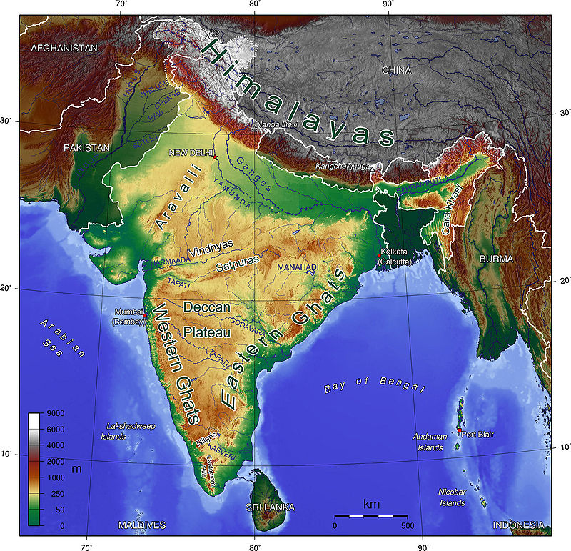
This is a big plain in the south of Himalayas which extends to approximately the whole of north India. It is made by Ganges, Bhrahmputra and Indus and their tributaries. In India most of it is in the area of the Ganges. The part related to Indus and its tributaries is mostly in Pakistan. Only the plain of Satluj, Ravi, and Beas is left in India. Similarly in the east the most of the delta of Ganges is in Bangladesh. The huge northern plain extends from west to east in India for approximately 2400 kilometers and is from 250 to 300 kilometers wide. The land is plain and rises gently towards west.
In the foothills of Himalayas (Shivaliks) where the rivers leave the hills and enter the plains, pebbles and stones are found in a narrow belt in which the water of the rivers sometimes gets lost. This sloping area is called Bhabhar. The rivers appear again in the south of Bhabhar. This region is full of swamps and forests. Hear smaller particles are found as compared to Bhabhar. It is planer as well. In some places agriculture is done here by clearing the forests. This is called lowlands or tarai. South of Tarai is the alluvial plain. Alluvium is of two types – old alluvium and new alluvium. ld alluvium is called Banagar. This is found in relatively higher land where the flood water of the river cannot reach. In some places limestone pebbles are found in it. New alluvium is called Khadar. This is found in the area of river flooding and in deltas where the rivers deposit new silt every year. In the southern region of the plain small hills coming out of the southern plateau are found at some places. Their examples are seen in the Gaya and Rajgir hills of Bihar.
Peninsular Plateau
The region to the south of the plains of north India is a large plateau. It is the remnant of the oldest land mass of the World. It is mainly made of hard and metamorphosed rocks. The plateau is surrounded on three sides by hills. In the north are the hills of Vindhyachal and Satpura, and Narmada flows between them towards the west. Vindhyachal is to the north of the Narmada valley and Satpura is to its south. The Satpura range separates north and south India. The eastern range is called Mhadev hill and Maikal range. Ajanta hills are to the south of Satpura.
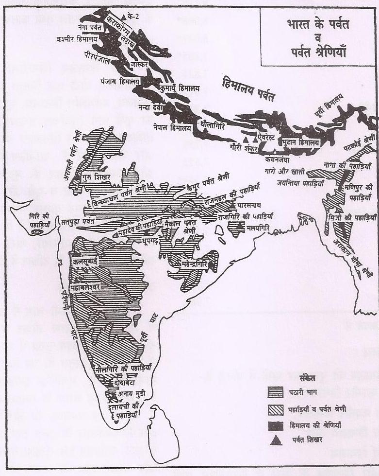
Western Ghats are on the western border of the peninsula and on the eastern border there are the hills of Eastern Ghats. Western Ghats are higher as compared to the Eastern Ghats and is approximately 3,500 feet high continuously for several hundred kilometers. Eastern Ghats are not only low they are cut at several places by the rivers which fall in the Bay of Bengal. From north to south the important rivers are Mahanadi, Godawari, Krishna and Kaveri. In the south the Western and Eastern Ghats meet in the Nilgiri hills where the Dodabetta peak is 8,760 feet high. The Annamali and Cardamom hills are to the south of Nilgiris. The highest peak of the Anemudi plateau of Anamali Hills is 8,840 feet high. The Plaghat pass is between these hills and Nilgiri hills through which a railway line goes towards west. Thalghat and Bhorghat are two important passes in the Western Ghats through which railway lines go to Mumbai.
In the north-west the Malwa plateau is between the Vindhyachal range and Arawali range, which is made of Lawa flows. The Arawali range extends from Gujarat in the south to Delhi in the north in the nature of many residual hills. Mount Abu (5,650 feet) is located in its highest south west end. Chhota Nagpur plateau is in the north east where Rajmahal hills make the north east boundary of the peninsular plateau. The shilong plateau of Assam is also a part of the peninsular plateau which has separated due to the Gangetic plain.
The average height of the southern plateau is 1500 to 300 feet. Slope is towards east. Except Narmada and Tapti al other rivers fall in the Bay of Bengal.
Coastal Plains
Fertile coastal plains are found on the western and eastern borders of the plateau. The western coastal plains are narrow. The northern part is called Kokan and the southern part is called Malabar Coast. Eastern plains are relatively wider and extend in the north from Odisha to Kumari promontory in the south. The plain becomes wider in the delta regions of Mahanadi, Godawari, Krishan and Kaveri deltas. The northern part of the plain is called the northern Circars coast.
Island Region
There are Lakshadweep in the Arabian Sea and Andaman and Nicobar Islands in the Bay of Bengal. Lakshadweep is made of corals. These are also called atolls. Andaman and Nicobar islands are considered to be a portion of Arakan Yoma which has drowned in the ocean and are in fact mountain rages which have sunk into the sea. Some remains of volcanic activity is also seen in the Andaman and Nicobar Islands. Barron Island in its west is the only volcano of India.